Shadow Diagram Consultant

A shadow diagram consultant is a professional who specialises in analysing and providing expertise on shadow diagrams for architectural projects, urban planning, environmental assessments, and other related fields. These consultants typically have expertise in:

  1. Solar Geometry: Understanding the principles of solar geometry, including the position of the sun relative to the Earth at different times of the day and year, as well as the factors influencing solar angles and shadow projections.

  2. Shadow Analysis Tools: Familiarity with tools and software for conducting shadow analysis, such as sun path diagrams, solar calculators, 3D modelling software, and GIS (Geographic Information Systems) applications.

  3. Regulations and Standards: Knowledge of relevant regulations, guidelines, and standards related to solar access, daylighting, energy efficiency, and environmental impact assessments, particularly in the context of architectural design and urban planning.

  4. Architectural Design: Understanding of architectural design principles and how shadows can impact building performance, occupant comfort, and aesthetic considerations.

  5. Urban Planning and Development: Awareness of urban planning principles and considerations, including the impact of shadows on public spaces, neighbouring properties, and overall urban form.

  6. Environmental Impact Assessment: Experience in assessing the environmental impacts of shadowing on ecosystems, vegetation, wildlife habitats, and microclimates, as well as strategies for mitigation and adaptation.

  7. Communication and Reporting: Ability to communicate complex shadow analysis findings effectively to clients, stakeholders, and project teams through clear visualisations, reports, and presentations.

When hiring a shadow diagram consultant, it's important to look for individuals or firms with relevant experience, qualifications, and a track record of successful projects in your specific context. They should be able to provide tailored advice and solutions to meet your project objectives, whether it involves optimising building design for solar access, complying with regulatory requirements, or mitigating adverse shadow impacts on the surrounding environment.

How do you calculate solar shadow?

Calculating solar shadows involves understanding the position of the sun relative to an object or structure and determining the resulting shadow cast by that object. Here's a basic method for calculating solar shadows:

  1. Determine the Sun's Position: The position of the sun varies throughout the day and year based on factors such as the time of day, time of year, and geographic location. You can use mathematical models or online tools such as sun path diagrams or solar calculators to determine the azimuth (horizontal angle) and altitude (vertical angle) of the sun at a specific time and location.

  2. Identify the Object Casting the Shadow: Determine the height and orientation of the object or structure that will cast the shadow. This could be a building, tree, pole, or any other vertical element.

  3. Calculate the Shadow Length: Use trigonometry to calculate the length of the shadow cast by the object. The length of the shadow will depend on the height of the object and the angle of the sun's rays. The basic formula for calculating the length of the shadow is:

    Shadow Length = Object Height / tan(Solar Altitude Angle)

    Where:

    • Object Height is the height of the object casting the shadow.

    • Solar Altitude Angle is the angle of elevation of the sun above the horizon.

    Note: Make sure to use consistent units (e.g., meters for height) and convert angles to radians if necessary for trigonometric functions.

  4. Draw or Visualize the Shadow: Once you have calculated the length of the shadow, you can draw or visualize it relative to the object casting the shadow. Draw a line extending from the top of the object at the angle corresponding to the solar altitude, and mark the end of the line to represent the tip of the shadow.

  5. Repeat for Different Times or Dates: If you're interested in understanding how the shadow changes throughout the day or year, repeat the calculation for different times or dates by adjusting the solar position parameters accordingly.

  6. Consider Surrounding Terrain and Obstructions: Keep in mind that shadows can be affected by surrounding terrain, buildings, trees, and other obstructions that may block or alter the shape of the shadow. Factor in these considerations when analyzing or predicting shadows in a real-world context.

By following these steps, you can calculate solar shadows and gain insights into how sunlight interacts with objects and structures in the built environment. Advanced software tools and models may also be available to automate and streamline the calculation process for more complex scenarios.

How to draw shadow diagrams

Drawing shadow diagrams involves depicting the projected shadows cast by buildings or structures at various times of the day or year. Here's a step-by-step guide on how to draw shadow diagrams:

  1. Select a Site and Orientation: Start by choosing the site for which you want to create the shadow diagram. Determine the orientation of the site, considering factors such as the cardinal directions (north, south, east, west) and the position of nearby buildings, trees, or other obstructions.

  2. Define the Time Intervals: Decide on the time intervals for which you want to analyze the shadows. Common intervals include hourly increments throughout the day or specific times corresponding to sunrise, midday, and sunset. You may also want to create diagrams for different seasons to account for variations in the sun's path throughout the year.

  3. Create a Base Plan: Sketch a simple base plan of the site, including the outlines of buildings, structures, trees, and any other relevant features. Use a scale that allows you to accurately represent the size and proportions of the site.

  4. Position the Sun: Determine the position of the sun for each time interval you've chosen. You can use resources like solar charts, sun path diagrams, or sun position calculators to find the azimuth (horizontal angle) and altitude (vertical angle) of the sun at different times of the day and year based on your location.

  5. Draw Shadow Lines: For each time interval, draw lines representing the direction of sunlight hitting the site and the resulting shadows cast by buildings or structures. Use the azimuth angle to determine the direction of the sunlight, and draw lines perpendicular to the sunlight direction to represent the shadows. The length of the shadow lines will depend on the height and orientation of the objects casting the shadows, as well as the altitude angle of the sun.

  6. Label and Annotate: Label the shadow lines with the corresponding time of day or year to provide context. You can also annotate the diagram with additional information, such as the date, specific sun angles, or any observations or insights gained from the analysis.

  7. Refine and Review: Review the shadow diagram to ensure accuracy and clarity. Make any necessary adjustments or refinements to improve the representation of shadows and the readability of the diagram.

  8. Optional: Digital Tools: If you prefer digital tools, you can use software programs or apps designed for architectural analysis or CAD (Computer-Aided Design) software to create more precise and detailed shadow diagrams. These tools often provide features for simulating sunlight, generating shadow projections, and visualizing the results in 3D models or digital renderings.

By following these steps, you can create shadow diagrams that effectively communicate the patterns and effects of sunlight on a site, helping inform design decisions and evaluate the impact of shadows on buildings, outdoor spaces, and surrounding environments.

Equinox shadows trace a straight line from west to east

Equinox shadows are unique

Do you enjoy sundials, and shadows? Did you know that – on the day of an equinox, and only on the day of an equinox – the tip of an upright stick’s shadow follows a straight west-to-east path? If you track the shadow’s tip (aka its terminus) as it moves across the ground on the day of the equinox, you’ll see it tracing out that straight line, as shown – beginning around 00:20 – in the video below:

Tracking the equinox sun

By tracking the sun’s shadow in this way, you’re making a simple kind of sundial. Sundials are the earliest type of timekeeping device.

This shadow fact – that is, the tip of a shadow traces a straight west-to-east path only at the equinoxes – applies everywhere worldwide, except at the North and South Poles.

In 2023, the equinox comes on September 23. So that’s a good day to see the equinox shadow for yourself.

Given a sunny day and an open sky, you can see the line traced by the moving shadow. Find a level spot, and pound your shadow stick (aka your gnomon) upright into the ground.

Alternatively, you could use an existing flagpole or utility pole as a makeshift shadow pole. Just be sure to have enough flat terrain to accommodate the moving shadow.

Try using spikes, coins or small rocks to record the shadow’s passing throughout the day. Remember, you’ll be recording the points struck by the shadow’s tip, or terminus. On the day of an equinox, these points will make a straight line, on or near a line from due west to due east.

About that word ‘gnomon’

A shadow pole or shadow stick, when used to track the sun by its shadow, is called a gnomon. Apparently, “gnomon” is an ancient Greek term meaning “to know”.

So the term seems appropriate because – after all – the gnomon’s shadow knows! The gnomon of a sundial, for example, knows both the hour of the day and the season of the year.

Curved shadow paths at other times of year

Then at other times of the year, but most especially at the solstices, the shadow paths follow a curve, as shown on the graphic below. Technically speaking, these nonlinear curves are called hyperbolas.

Worldwide similarities of shadow paths

In both the Northern and Southern Hemispheres, the morning’s longest shadow happens right after sunrise. Midway between sunrise and sunset, the shortest shadow of the day occurs at solar noon. Then, after noon, the shadow starts to elongate again, with the longest afternoon shadow happening just before sunset.

Once again, on the day of an equinox, the tip of an upright pole’s shadow travels in a straight line, from west to east.

Here are more experiments you can do yourself at home.

Northern and Southern Hemisphere differences

By the way, there are some major differences between the two hemispheres. On an equinox-day in the Northern Hemisphere, the straight shadow path passes to the north of the gnomon. In the Southern Hemisphere, the straight shadow path passes to the south of the gnomon.

And, at the equator, the shadow path goes neither north nor south of the gnomon. That’s because the noonday sun swings directly over the upright pole on the equinox, casting no midday shadow.

FULL ARTICLE

Your ‘Right To Light’: Solar Panel Overshadowing Rules By State


Overshadowing of solar panels by new neighbouring developments is a recurring problem that some SolarQuotes readers have first-hand experience with. This is an issue that’s not going away soon. It’s only getting worse as our cities grow.

I can’t say I have a silver bullet solution to keep the light shining on your solar panels, but knowledge is power. This post is aimed at getting you familiar with the rules in your jurisdiction if there are any, so you know whether you have a ‘right to light’.

Laws And Regulations Around Overshadowing

In Australia, there is no single law that protects your rooftop solar panels from being overshadowed by a neighbouring development. Instead, each local council has its own set of policies that are often guided by state government regulations.

These regulations vary from state to state, and although most have some consideration for your so-called ‘solar access’, they usually fall short of fully protecting the unobscured path of sunlight to your solar panels. In fact ‘solar panels’ are barely mentioned.

Local councils have to strike a balance between promoting development and not impinging on the well-being of nearby residents. As a result, the policies are sometimes grey and open to interpretation. Depending on which side of the fence you live, that ‘balance’ can look a little lopsided.

Inevitably, many disputes are handled on a case-by-case basis to find an amicable resolution, and going to court would be a last resort. Having said that, some legal challenges have successfully stopped overshadowing developments in the past.


Summary Of Your ‘Right To Light’ Rules By State/Territory

New South Wales

Guidelines specify that there must be at least 3 hours of sunlight between 9 am and 3 pm at the winter solstice to 50% of the PPOS (Principal Private Open Space) of both the proposed development and neighbouring properties.

Victoria

Amendment VC149 and PPN88 require planning applications to minimise the impact of overshadowing on existing rooftop solar panels on adjoining lots.

Queensland

No specific right to sunlight, but vague mention in the Queensland Development Code of height restrictions to prevent undue overshadowing.

Western Australia

Planning guidelines include limits on shadow cast at midday, 21st June, depending on the zone of the adjoining properties.

South Australia

The Planning and Design Code outlines criteria for minimising overshadowing, including a 30-degree plane grading from a height of 3m above ground level at the southern boundary for residential zones.

Tasmania

The Tasmanian Planning Scheme stipulates that developments should not cause an unreasonable reduction in sunlight to existing solar installations on adjoining or the same property.

Australian Capital Territory

The Territory Plan 2008 states that buildings should not overshadow windows of habitable rooms or any principal private open space on an adjoining residential block more than the height of a ‘solar fence’.

Northern Territory

Relatively lax regulations with general requirements that structures should not result in a significant loss of amenity in terms of lighting and overshadowing.

Detailed Breakdown: State-By-State

Below is a more detailed overview of current regulations and policies addressing overshadowing for new developments. It’s not an exhaustive list and may not relate to your situation, so seek legal advice if you think you need it.

New South Wales

In New South Wales a DCP (Development Control Plan) is a planning document that provides detailed guidelines and controls for the development of land within a particular area. DCPs are specific to each local government area.

Most DCPs stipulate a requirement of at least 3 hours of sunlight between 9 am and 3 pm at the winter solstice (21 June) to 50% of the required PPOS (Principal Private Open Space) of both the proposed development and the neighbouring properties. This figure may vary depending on factors such as region, density, and type of property.

Victoria

In 2018 an amendment (VC149) was made to the Victoria Planning Provisions to ensure that “new building designs minimise the impact of overshadowing of existing rooftop solar energy facilities on adjoining lots.”

PPN88 (Planning Practice Note 88) states that a planning permit application should include the following information:

  • The location of any existing domestic rooftop solar energy system on a dwelling on an adjoining lot and the extent of any existing overshadowing.

  • Shadow diagrams that illustrate the extent of overshadowing created by the building and works on any existing domestic rooftop solar energy system.

  • A written statement outlining how overshadowing of any existing domestic rooftop solar energy system is proposed to be mitigated.

It’s not all sunshine and roses for solar owners though as the provisions throw part of the onus back on them. It goes on to say: “Relevant factors to consider in determining whether the impact of a development is unreasonable include:

  • Whether the siting of the existing domestic rooftop solar energy system takes into account the potential future development of adjoining lots promoted or permitted under the planning scheme.

  • The extent to which the existing domestic rooftop solar energy system has been located to protect it from overshadowing through placement higher on the roof and further from existing lot boundaries.”

Queensland

Despite Queensland claiming to be the sunshine state, the law there doesn’t recognise any right to sunlight! The Property Law Act 1974 (Qld) states that “no right to the access or use of light for any building shall be deemed to exist, or to be capable of coming into existence, merely because of the enjoyment of such access or use for any period or of any presumption of lost grant based upon such enjoyment.”

Contradicting the above bizarre legislation, overshadowing caused by buildings is given a vague mention in the Queensland Development Code (QDC) parts MP 1.1, MP 1.2, and MP 1.3. Performance criteria state that “The height of a building is not to unduly overshadow adjoining houses.” ‘Acceptable solutions’ for a developer are given as various height restrictions based on lot sizes and slope angles.

Western Australia

Local council policies regarding solar access and overshadowing in WA are guided by the State Planning Policy 3.1 Residential Design Codes.

Developers’ applications must include ‘Plans and sections of sufficient information to explain how the adjoining property as a whole would be affected by overshadowing.’

In addition, “Development in climatic zones 4, 5 and 67 shall be so designed that its shadow cast at midday, 21st June onto any other adjoining property does not exceed the following limits:

  • on adjoining properties R25 and lower – 25% of the site area.

  • on adjoining properties R30 to R40 inclusive – 35% of the site area.

  • on adjoining properties higher than R40 – 50% of the site area.”

Methodology and explanatory guidelines are given on the calculation of overshadowing for developer applications.

South Australia

The South Australian Planning and Design Code is the go-to document that local councils use in the assessment process for a new development application.

The Planning and Design Code sets criteria for different zones and general development policies that address requirements such as minimisation of overshadowing for a multi-story building.

For instance, the code stipulates that one performance outcome may be: “Buildings mitigate overshadowing of residential development within a neighbourhood-type zone.”

The outcome ‘deemed to satisfy’ under the code would be: “Buildings on sites with a southern boundary adjoining the allotment boundary used for residential purposes within a neighbourhood-type zone are constructed within a building envelope provided by a 30-degree plane grading north measured from a height of 3m above natural ground level at the southern boundary.”

‘Plan SA’ has a tool where you can find and track development applications from lodgment to decision. Simply type in the address, or search via an online map.

Tasmania

Land development applications in Tasmania have typically been overseen by the relevant local council planning scheme, however, most are transitioning to the Tasmanian Planning Scheme. Once complete, each development application will also be subject to local council ‘special provisions’.

The Tasmanian Planning Scheme mostly makes reference to overshadowing and reduction in sunlight to “habitable rooms and private open space of dwellings”, specifying wall heights and building setbacks in different zones.

The scheme also states that “the siting and scaling of a dwelling must not cause an unreasonable reduction in sunlight to an existing solar energy installation on (i) an adjoining property; or (ii) another dwelling on the same site.” ‘Acceptable solutions’ for the developer include defined wall heights and setbacks as above.

Australian Capital Territory

The ACT (Australian Capital Territory) doesn’t have traditional LGAs (Local Government Areas) or local councils as found in other states. All land development applications are administered through the ACT Environment, Planning and Sustainable Development Directorate.

Under the Territory Plan 2008, the Single Dwelling Housing Development Code states that “buildings do not overshadow the windows of habitable rooms (other than bedrooms), any principal private open space, reasonable levels of solar access of any dwelling on an adjoining residential block at noon on the winter solstice to a greater extent than the height of the ‘solar fence’ on a northern boundary of that block.”

Northern Territory

Similarly to the ACT, the Northern Territory administers all new development applications through the NT Government. They’re a bit more casual about potential overshadowing up there, as the sun is much higher in the sky most of the time. The NT Planning scheme – part 5 development requirements cover anything they are bothered about, which is not much.

“Requirement – Any structure associated with the use does not result in a significant loss of amenity for surrounding development, having regard to the extent and duration of lighting and overshadowing.”

That’s all!

Dispute Resolution

All local councils have a dispute resolution process, so if your solar power system is affected it’s important to find out what that is in relation to your overshadowing issue. It’s not within the scope of this post to detail the requirements of over 500 local government areas within Australia.

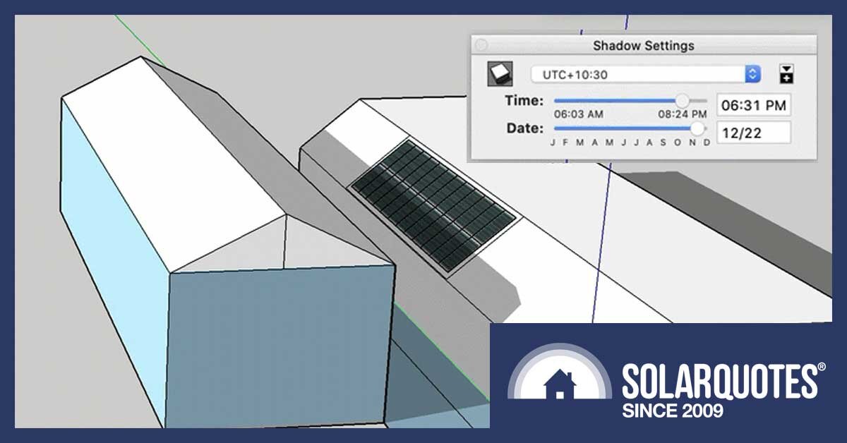
All I can say is review the regulations above, as well as any others that may be applicable. Keep detailed documentation of events as they occur, and get legal advice. Hopefully, you’ll never have to see the inside of a courtroom. The following are links to some case studies to give you food for thought… oh, and this DIY shadow analysis article might come in handy.

Case Studies

Prestige Building Services Pty Ltd v Coffs Harbour City Council [2005]

The Benevolent Society v Waverley Council [2010] 

Chen v Melbourne CC & Ors (Red Dot) [2012] 

Kelly & anor v Dehnert & anor [2015] 

Ramjee v Manningham CC (Red Dot) [2020] 

Ned Ritan Design v The Corp of the City Of Adelaide [2016] 

From My Side Of The Fence

The absence of a national standard to address developments overshadowing solar panels in Australia places the onus on individuals to navigate a web of state specific policies. From my side of the fence, those policies appear to be either thin on the ground or very lopsided. What do you reckon?

FULL ARTICLE

What is shadow analysis in architecture

Shadow analysis in architecture refers to the process of studying and evaluating how sunlight interacts with a building or urban environment. It involves analysing the patterns and effects of shadows cast by buildings, structures, and natural elements such as trees and hills throughout different times of the day or year.

Architects use shadow analysis for various purposes, including:

  1. Design Optimisation: Understanding how shadows will fall on and around a building helps architects optimise the design for natural lighting, shading, and energy efficiency. This includes positioning windows, designing shading devices, and determining the orientation of the building to maximise daylighting and minimise glare and solar heat gain.

  2. Urban Planning: In urban environments, shadow analysis helps planners assess the impact of new developments on surrounding buildings, streets, and public spaces. It helps ensure that new buildings do not excessively shade important public areas or adjacent properties, and that sunlight is preserved in key locations.

  3. Aesthetic Considerations: Shadows can play a significant role in the aesthetic appeal of a building or space. Architects may use shadow analysis to create visually compelling designs by manipulating light and shadow to enhance architectural features or create dramatic effects.

  4. Environmental Impact Assessment: Shadow analysis is often part of environmental impact assessments for proposed developments. It helps evaluate potential impacts on microclimates, vegetation, and wildlife habitats resulting from changes in sunlight patterns.

  5. Solar Access: In some jurisdictions, there may be regulations or guidelines regarding solar access rights, ensuring that neighbouring properties receive sufficient sunlight for solar energy systems, gardening, or other purposes. Shadow analysis helps assess compliance with these requirements.

Shadow analysis can be conducted using various tools and techniques, including physical scale models, computer simulations, and advanced software programs that simulate sunlight patterns based on geographic location, time of day, and time of year. By conducting shadow analysis early in the design process, architects can make informed decisions to create more sustainable, functional, and visually appealing buildings and urban environments.


Overshadowing Neighbours in Residential Property

Overshadowing neighbours in a residential property can be a contentious issue and often relates to how one property's structure or landscaping may block sunlight or obstruct views to the detriment of adjacent properties. It's essential to address this matter with sensitivity and respect for your neighbours and to consider local regulations and standard practices when dealing with overshadowing concerns. Here are some key points to keep in mind:

  1. Local Regulations: Check with your local government or municipality to understand the zoning and building regulations that pertain to overshadowing. Many places have specific rules to address overshadowing issues, such as setback requirements and height restrictions.

  2. Survey the Situation: Before taking action or making any changes to your property, assess the current situation. Consider the angles and directions of sunlight throughout the day and how your property may affect neighbouring properties regarding shade or loss of natural light.

  3. Consult Your Neighbours: Discussing your plans or concerns with your neighbours is a good idea. Open communication can often lead to a mutually agreeable solution or compromise. They may have suggestions or concerns that you still need to consider.

  4. Consider Property Boundaries: Ensure you know your property boundaries and any relevant easements. It would help if you did not infringe on your neighbour's property or restrict their access to sunlight or views in a way that goes against property laws.

  5. Design and Landscaping: If you are planning renovations, additions, or landscaping changes that could affect neighbouring properties, try to design them in a way that minimises overshadowing. This might involve strategic placement of structures or vegetation to mitigate shade.

  6. Arbitration or Mediation: If you and your neighbours cannot agree on overshadowing concerns, consider mediation or arbitration to resolve the issue without legal action.

  7. Legal Recourse: In extreme cases where local regulations are being violated, neighbours may have legal recourse. They can file complaints with local authorities, who can then investigate the matter and enforce relevant regulations.

  8. Documentation: Keep records of discussions, agreements, or disagreements with your neighbours regarding overshadowing issues. This documentation can be helpful if the matter escalates or if you need to show that you have taken reasonable steps to address any concerns.

Remember that property disputes, including overshadowing issues, can be emotionally charged. It's usually in everyone's best interest to find an amicable solution through communication and negotiation rather than resorting to legal action. Consulting with a local attorney specialising in property law can also provide valuable guidance in navigating overshadowing concerns in your jurisdiction.

Stony Range Regional Botanic Garden To Be Permanently Overshadowed By Approved Development: A Death Knell For Dee Why's Bush Reserve

Council recommended for approval a development which will overshadow the historic Stony Range Botanical Garden at Dee Why year-round. 

Due to the development being over 60 million dollars DA2022/0145 went to the Sydney North Planning Panel with council’s recommendation and was approved on Monday July 17 2023. There were 134 submissions, many objecting to the DA as it is, along with those from local Real Estate agents and Developers, who have voiced support for the DA stating it will provide affordable housing. The median price for a unit in Dee Why is $865,000 (July 2022 - June 2023) for a 2 bedroom unit the median price is $915,000 and $1,402,500 for a 3 bedroom unit.

All but one member of the SNPP approved the development. That one member recommended refusal of the proposal because of ‘’the significant impact (by overshadowing) of the design of the proposal on the recreational amenity of a portion of Stony Range Reserve used for play, picnics and BBQs.’’

The available shadow diagrams indicate that overshadowing would occur over much of the play/picnic/BBQ area across the middle of the day in winter and also but to a lesser extent in autumn and spring.

Despite the SNPP recording in its decision that ‘’Therefore, the development does not avoid ‘unreasonably overshadowing’ a part of the reserve that makes a substantial contribution to its’ recreational amenity.’’ the DA was approved.

Specifically, the proposal involves the following:

  • Demolition of all structures, including existing commercial buildings and carparking areas

  • Removal of 59 trees

  • Bulk excavation of the site

  • 334 car parking spaces (258 residential, 44 visitor and 32 commercial) in two basement levels

  • Vehicular access, loading dock and waste collection from Delmar Parade

  • Two main buildings, with varying heights, including five, six and seven storeys

  • 219 apartments; comprising 122 units in the Delmar Parade building (being 44 x 1 bed, 8 x 1 bed+, 30 x 2 bed, 16 x 2 bed+, 21 x 3 bed, and 3 x 3 bed+) and 97 units in the Pittwater Road building (being 35 x 1 bed, 6 x 1 bed+, 35 x 2 bed, 6 x 2 bed+, 12 x 3 bed, and 3 x 3 bed+) – so 384 car spaces potentially required, 258 allowed for residential parking leaves a shortfall of 126 spaces

  • Four (4) commercial tenancies, two facing Pittwater Road and two facing Delmar Parade 

  • 2,011m2  of communal open space, including ground floor level and roof top terraces

  • Relocated stormwater infrastructure and Overland Flow Path

  • New landscaping

READ MORE

Merri-bek Council rejects proposed development blocking neighbour’s sunlight

In a win for those opposed to inappropriate development in Melbourne, Socialist Alliance councillor for Merri-Bek Sue Bolton’s motion to refuse a planning permit to a seven-storey apartment building that would have blocked a neighbour’s access to sunlight passed unanimously on March 22.

The proposed apartments would have overshadowed the neighbouring family’s single-storey home, leaving them with just two hours of sunlight a day.

Nine-storey Braddon apartment proposal overshadowing within rules, says proponent

Overshadowing concerns from the neighbouring Phoenix Apartments in Braddon have not altered plans for a nine-storey mixed-use development that will add a further 105 apartments to the Northbourne corridor.

Canberra-based property group Liebke and Co have lodged a development application for the project to be built on a 2090 square metre rectangular site at 90 Northbourne Avenue in Braddon (Block 1 Section 19).

The pre-DA consultation report said the loss of sunlight was the main concern from residents in 38 north-facing units in the Phoenix Apartments, with many wanting the developer to reconsider the building height or design.

The proponent acknowledges that the building will reduce the amount of sunlight the Phoenix will receive, especially within the winter months, but believes the proposal is still within the planning rules, saying the affected in the adjoining block will receive more than two hours of direct sunlight between 9 am and 4 pm for many days of the year, as required.

The DA says this is considered reasonable given the short five-metre setback northern boundary and the constrained nature of the subject block.

Any reduction in building height or change to the design redesigns will affect the viability of the project, given the purchase value of the site and its small size, the DA prepared by Purdon Planning says.

Throwing shade: Stony Range Botanic Garden to be overshadowed by apartments

A development application for apartments at the junction of 4 Delmar Parade and 812 Pittwater Rd, Dee Why, is set to proceed after the construction scheme was approved by the Sydney North Planning Panel.

However, users of neighbouring Stony Range Botanic Garden are concerned that parts of the bushland site will be overshadowed by the proposed high-rise, stating that picnic areas and native flora will be shaded by an eight-storey building for significant periods of the year, threatening the survival of trees and plant life.

A spokesperson for Stony Range Volunteer Advisory Committee, which, along with Northern Beaches Council, oversees the management of the 3.3 hectare public garden, told Manly Observer, “We are not trying to stop the development, merely to reduce its negative impacts on Stony Range…”

READE MORE

Understanding Victorian planning regulations

Rule 9: Thou shalt not steal thy neighbour’s daylight

The regulation:
 ‘54.04-3 Standard A12 – Daylight to existing windows regulation 416’

This standard states that buildings opposite an existing habitable room window shouldprovide for a light court to the existing window that has a minimum area of 3 square metres and minimum dimension of 1 metre clear to the sky.

It also states that walls or carports more than 3 metres in height opposite an existing habitable room window should be set back from the window at least 50 per cent of the height of the new wall, if the wall is within a 55 degree arc from the centre of the existing window.

Translation: You need to allow light into your neighbour’s existing windows. In order to do this, you must provide a minimum area of 3 metres square with 1 metre clear to the sky around your neighbour’s window. This area can be calculated from either yours or your neighbour’s property.

Solution: Create courtyard and garden spaces similar to the standard before. This will allow light not only into your neighbour’s windows but also into your own.

Rule 10: Thou shalt protect the energy efficiency of thy neighbours

The regulation: ‘54.04-4 Standard A13 – North facing windows regulation 417’

Here, we are told that if a north-facing habitable room window of an existing dwelling is within 3 metres of a boundary on an abutting lot, a building should be set back from the boundary 1 metre, plus 0.6 metre for every metre of height over 3.6 metres up to 6.9 metres, plus 1 metre for every metre of height over 6.9 metres, for a distance of 3 metres from the edge of each side of the window.

Translation: You need to preserve your neighbour’s northern sun and if their window is within 3 metres of the boundary, you must set back your building 1 metre plus 0.6 metres for every metre higher than 3.6 metres. This continues until 6.9 metres – every metre after that, you must set back your house another metre.

Solution: Note where your neighbour’s north-facing windows are before you design your building, so that you can plan around them early rather than getting nasty shocks later during the planning process.

READ MORE

New Victorian regulations to prevent overshadowing solar panels

The Victorian state government has announced regulations to prevent overshadowing solar panels by new developments.

The new rulings will apply under amendments to the Victorian Planning Provisions and will come into effect in late September of 2018.

This means that in the future all planning schemes will need to consider how new developments impact on neighbouring properties that have existing solar installations. This includes properties with existing rooftop solar panels and solar hot water systems.

READ MORE

Solar panels and the law: Can you stop your neighbour from blocking your sunlight?

What rights exist around access to light?

As of April 2017, 1.6 million properties around Australia had photovoltaic solar panels — and new figures from the Australian Photovoltaic Institute show the country's solar power capacity is expected to double over the next few years.

So what does Dr Thomas's case mean for the rest of the country's solar panel owners? Do they have a right to sunlight without overshadowing?

READ MORE

Updated | Planning panel says additional overshadowing of Monro Park among 'significant issues' with Cronulla hotel proposal

r0_449_5315_3437_w1200_h678_fmax.jpg

Plans for a 13-storey hotel on the edge of Monro Park at Cronulla have received a major setback.Sutherland Shire Local Planning Panel recommended this week the Planning Proposal be reconsidered because of "significant issues", including additional overshadowing of the park and war memorial.

READ MORE

James Packer's proposed tower to cast a long shadow at Barangaroo

James Packer's $2 billion tower at Barangaroo would literally be throwing shade at its competitor, documents show.

Crown Limited's proposed hotel, casino and apartment complex would extend a shadow as far as Sydney's only existing casino at Pyrmont, according to modelling lodged with the Department of Planning and Environment.

Of the four scenarios considered, the Crown tower would block some of Sydney's morning sun out as far as The Star during the June solstice, as indicated by the red outline.

During the same part of the day on March 21, the building would cast a shadow across Jones Bay wharf, which is about 550 metres away.

READ MORE

Developer refuses to reduce height, design of large Bruns DA

A controversial dual occupancy development proposed for Brunswick Heads looks set to be rejected by Byron Council, after council staff changed their advice, and recommended refusal.

The owner of 16 Short Street, a Melbourne-based property developer, is seeking permission to demolish the existing single-storey cottage on the site and replace it with two large, double storey townhouses, each with five bedrooms and five bathrooms.

READ MORE